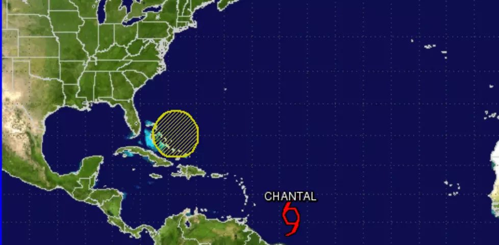
This low is not the real story. The real story is that it just popped up in the Gulf. Sure it is late in the season; but this proves it is not time to let our guard down.
You know how it works. Everyday we watch the storms path extended eastward. As the path is extended we learn more about the storms destination. The last extension on Dorian shows the storm could impact the gulf.
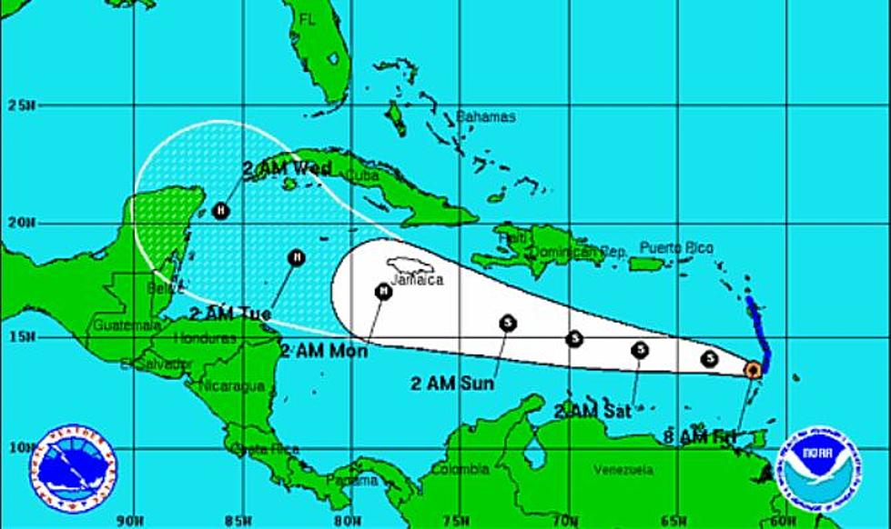
Tropical Storm Chantal has formed in the Atlantic north of the coast of French Guiana. At this time it looks like the storm could impact the Dominican Republic and Puerto Rico this week as a tropical storm. Then is heads in the general direction of Florida.
I hate the term "disturbed weather." Did someone wake this weather up from a nap or do something to make it mad? Regardless .... there is a weak low pressure system over the south-central Gulf of Mexico and forecasters are watching it for tropical formation.
I worked with a Barbara one time. She could certainly stir things up! I would expect a tropical system baring her name to be a bit more stubborn. According to the National Hurricane Center the first system of the year will die while making an attempt to cross from the Pacific to the Gulf of Mexico.
UPDATE 7 p.m., 8/27 -- 26.7 N, 86.5 W, 70 mph, 981 mb: Isaac still remains too ragged to become strong enough to be a hurricane, but it is expected to get stronger overnight. Officials are becoming more concerned about the storm surge that will likely push ashore near the Louisiana/Mississippi border, and are also concerned that Isaac will come ashore near New Orleans and simply sit there dumping
Sometime in the middle of next week, Tropical Storm Ernesto will likely be making landfall on the shores of the Gulf of Mexico -- but exactly where is still a mystery. And while Ernesto is throwing out winds of around 50 mph this morning, it's still uncertain at this hour just how strong he'll become.
There is something brewing in the Caribbean which could make it into the Gulf of Mexico by this weekend. Here is the lastest details from my buddy Wade Hampton from KPLC on a development of the weather in the Gulf of Mexico.
The Pacific hurricane season officially starts today and it's already off to an active start. The first named tropical system of the hurricane season has formed in the Pacific Ocean and her name is Aletta. Tropical Storm Aletta as you can see by the picture is up to 45 mph and it not expected to make landfall anywhere.
Chief Meteorologist Wade Hampton from KPLC sent us the details.
As a precaution, the Calcasieu Parish Police Jury has issued a state of emergency declaration just in case Tropical Storm Lee heads this way. According to the jury, the Office of Homeland Security and Emergency Preparedness will remain active in monitoring the weather system and address any safety issues as they develop.
Tropical Storm Emily will move over the southwestern peninsula of Haiti later Thursday on its way to Cuba, with an expected landfall on the island country later today or early Friday, according to the latest National Hurricane Center advisory.